The caves of Paleokastritsa EarthCache
The caves of Paleokastritsa
-
Difficulty:
-

-
Terrain:
-

Size:  (other)
Please note Use of geocaching.com services is subject to the terms and conditions
in our disclaimer.
[ENG]
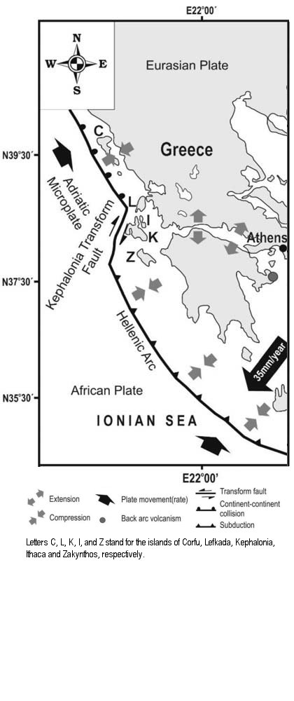
Corfu Island lies on the North-Western edge of the Hellenic Fold and Thrust Belt system of Greece. The geodynamic processes in the region are related to the active subduction of the African lithosphere beneath the Eurasian plate, which progressively becomes continental convergence in north-western Greece at South of Corfu. The transition occurs along the Kephalonia Fault Zone a prominent dextral strike slip fault, located offshore west of Kephalonia and Lefkas islands. The geological complexity of the area corresponds to the collision and convergence of the African and Eurasian plates since the Mesozoic. Limestone and submarine clastic sedimentations took place during the Mesozoic and Tertiary. During the Miocene, further activity of the thrust in Corfu resulted to the uplift of the sediments forming the island.
The vertical motion reconstructions of Corfu reveal a strong uplift. In northern Corfu, the base uplifted by approximately 1200 m near Paleokastritsa to 300 m at the northest coast of Corfu. This differential uplift is in agreement with the observed tilt of northern Corfu.
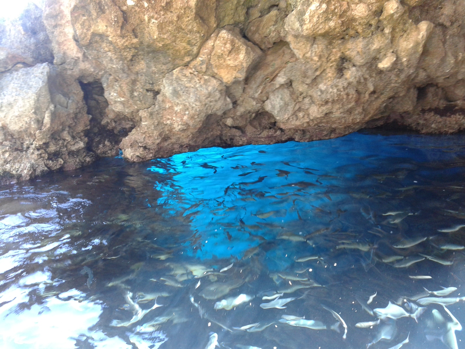
The rocks emerged by the uplift are sedimentary clastic rocks, well visible in Paleokastritsa. Clastic rocks are composed of fragments or clasts of pre-existing minerals and rock. A clast is a fragment of geological detritus and smaller grains of rock broken off other rocks by mechanical processes. Coarse grains are typically held together by a finer grained matrix and limestone. These rocks are often subdivided into conglomerates and breccias. The amount of rounding allow to distinguish these two categories: conglomerates are well rounded, while in breccias are angular. The action of the sea on the cliffs in Paleokastritsa is the main responsible for the erosion and fragmentation of the rocks, and in turn, it is responsible for the producion the caves.
Note on Terrain value
T value is 5 because you need a boat or a diving equipment to reach GZ, in agreement with Groundspeak guidelines. Actually, it's easy to reach the caves by boat with a tour. You'll pay for it. DON'T SWIM TO THE CAVES WITHOUT DIVING EQUIPMENT.
To log the EarthCache
Please send me a message or an e-mail with the following answers (only Italian or English are accepted languages):
1) What is the geological origin of Corfu?
2) Where did the rocks of the caves come from?
3) Just outside the cave no. 4 (Blue Eye cave), at the listing coordinates, sedimentary rocks are visible. Please describe that rocks.
4) Post pictures of the wonderful blue sea with swimming fishes by the cave no. 4 (Blue Eye).
(Google Translator was used for Greek translation. If you can provide a better translation, please contact the owner)
[GRE]
Κέρκυρα βρίσκεται στο βορειοδυτικό άκρο της Ελληνικής Διπλώστε και Ώθηση σύστημα Ζώνη της Ελλάδα. Οι γεωδυναμικών διεργασιών στην περιοχή που σχετίζονται με την ενεργό καταβύθισης της αφρικανικής λιθόσφαιρας κάτω από την Ευρασιατική πλάκα, η οποία γίνεται σταδιακά ηπειρωτικής σύγκλισης στη βορειοδυτική Ελλάδα στα νότια της Κέρκυρας. Η μετάβαση πραγματοποιείται κατά μήκος της Κεφαλονιάς ρήγματος σε περίοπτη δεξιόστροφη ρήγμα ολίσθησης, που βρίσκεται δυτικά των υπεράκτιων νησιά Κεφαλονιά και Λευκάδα. Η γεωλογική πολυπλοκότητα της περιοχής Αντιστοιχεί στη σύγκλιση και σύγκρουση της Αφρικανικής και Ευρασιατικές πλάκες από τότε Μεσοζωικού. Ο ασβεστόλιθος και κλαστικά υποβρύχιο sedimentations έλαβε χώρα κατά τη διάρκεια του Μεσοζωικού και Τριτοβάθμια. Κατά τη διάρκεια της Μειόκαινο, περαιτέρω δραστηριότητα της ώσης είχε ως αποτέλεσμα Κέρκυρα στην ανύψωση των ιζημάτων που σχηματίζουν το νησί.
Η κατακόρυφη κίνηση της ανακατασκευές Κέρκυρας αποκαλύπτουν μια ισχυρή ανάταση. Στη βόρεια Κέρκυρα, ανυψώθηκε από την βάση κοντά Παλαιοκαστρίτσα Περίπου 1200 m έως 300 m σε βορειότερο ακτή της Κέρκυρας. Αυτή η διαφορική ανύψωση είναι σε συμφωνία με την Παρατηρήθηκε κλίση της βόρειας Κέρκυρας.
Τα βράχια Αναδύθηκε από την ανάταση είναι κλαστικά ιζηματογενή πετρώματα, καλά ορατό στην Παλαιοκαστρίτσα. Τα κλαστικά πετρώματα που αποτελούνται από θραύσματα ή κλαστικά της προϋπάρχουσας μέταλλα και ροκ. Ένα clast είναι ένα θραύσμα της γεωλογικής τρίμματα και μικρότερους κόκκους του βράχου διακόπηκαν βράχων από άλλες μηχανικές διαδικασίες. Δευτερεύοντα σιτηρά Τυπικά συγκρατούνται μεταξύ τους από μια μήτρα πιο λεπτομερειακή και ασβεστόλιθο. Συχνά Αυτά τα πετρώματα χωρίζονται σε ομίλους και λατυποπαγή. Το ποσό της στρογγυλοποίησης Αυτά επιτρέπουν να διακρίνουμε δύο κατηγορίες: ομίλων είναι καλά στρογγυλεμένη, ενώ στην λατυποπαγή είναι γωνιακό. Η δράση της θάλασσας πάνω στα βράχια στην Παλαιοκαστρίτσα είναι ο κύριος υπεύθυνος για τη διάβρωση και τον κατακερματισμό των βράχων, και με τη σειρά της, είναι υπεύθυνη για την producion τα σπήλαια.
Σημείωση για Terrain αξίας
Τ τιμή είναι 5 Επειδή Χρειάζεται μια βάρκα ή ένα καταδυτικό εξοπλισμό για να φτάσει GZ, σε συμφωνία με τις κατευθυντήριες γραμμές Groundspeak. Στην πραγματικότητα, είναι εύκολο να φτάσετε στα σπήλαια με βάρκα με μια περιήγηση. Θα πληρώσουν για αυτό. ΜΗΝ να κολυμπήσουν μέχρι τις σπηλιές ΧΩΡΙΣ ΥΛΙΚΟ DIVING.
Για να συνδεθείτε η EarthCache
Παρακαλώ να μου στείλετε ένα μήνυμα ή ένα e-mail με τις ακόλουθες απαντήσεις (μόνο ιταλικά ή Inglese γλώσσες που γίνονται δεκτές): ΙΤΑΛΙΑ
1) Ποια είναι η προέλευση της Κέρκυρας;
2) Από πού προέρχονται τα βράχια των σπηλαίων?
3) Ακριβώς έξω από το σπήλαιο δεν είναι. 4 (μπλε μάτι λατομεία), στις συντεταγμένες λίστα, ιζηματογενή πετρώματα είναι ορατά. Σας παρακαλούμε να περιγράψετε Αυτό Rocks.
4) Παρακαλούμε να δημοσιεύσετε φωτογραφίες από το υπέροχο γαλάζιο της θάλασσας με τα ψάρια κολύμπι από το σπήλαιο δεν είναι. 4 (Μπλε Μάτι).
(Google Translator χρησιμοποιήθηκε για την ελληνική μετάφραση. Εάν μπορείτε να προϋπόθεση για την καλύτερη μετάφραση, παρακαλώ επικοινωνήστε με τον ιδιοκτήτη)
[ITA]
L'isola di Corfu si trova sul bordo nord-occidentale del sistema Hellenic Fold and Thrust Belt della Grecia. I processi geodinamici della regione sono realtivi all'azione di subduzione della placca africana al di sotto della placca eurasiatica, che progressivamente diventa di convergenza continentale nella Grecia nord-occidentale subito a sud di Corfù. La transizione avviene lungo la faglia di Cefalonia, localizzata a largo delle isole di Cefalonia e Leucade. La complessità geologica dell'area è dovuta alla collisione e convergenza delle placche africana ed eurasiatica sin dal Mesozoico. La sedimentazione calcarea e la sedimentazione clastica sottomarina hanno avuto luogo durante il Mesozoico e il Terziario. Nel Miocene, ultriore attività geologica a Corfù ha portato al sollevamenteo del calcare mesozoico che ha formato l'isola.
La riscotruzione del movimento verticale di Corfù lascia supporre che ci sia stato un forte sollevamento. La regione settentrionale di Corfù si è sollevata di circa 1200 m vicino a Paleokastritsa e di 300 m nel punto più a nord della costa. Questa differenza di sollevamenteo è in accordo con la pendenza dell'area settentrionale di Corfù.
Le rocce emerse sono rocce clastiche sedimentarie, ben visibili a Paleokastritsa. Le rocce clastiche sono composte da frammenti o clasti di minerali e rocce preesistenti prodotte dell'azione meccanica e dalla rottura di altre rocce. Tipicamente i granuli di grandi sono tenuti insieme da una matrice di granuli più fini e calcare. Queste rocce sono spesso classificate come conglomerati e brecce. La quantità di angoli spigoli arrotondati permette di distinguere i due tipi: i conglomerati hanno spigoli ben arrotondati, mentre le brecce hanno spigoli vivi. L'azione del mare sulle scogliere emerse a Paleokastritsa è il principale responsabile dell'erosione e della frammentazione delle rocce, e quindi della creazione delle grotte.
Nota sul valore del Terreno
Il valore di T è 5 in accordo con le linee guida di Groundspeak in quanto per raggiungere GZ è necessario l'uso di una imbarcazione o di attrezzatura subacquea. In realtà è facile raggiungere le grotte con i tour a pagamento che partono dalla spiaggia. NON NUOTATE FINO ALLE GROTTE SENZA ATTREZZATURE E SEGNALATORI.
Per loggare l'EarthCache
Per loggare l'EarthCache dovete inviarmi un messaggio o una e-mail con le risposte in italiano o in inglese ai seguenti quesiti:
1) Qual è stata l'origine geologica di Corfù?
2) Qual è l’orgine delle rocce che formano le grotte?
3) Appena fuori della grotta n. 4 (Blue Eye cave), alle coordinate del listing, sono ben visibili delle rocce sedimentarie. Per favore descrivi queste rocce.
4) Carica fotografie dello spettacolare mare azzurro ricco di pesci che si vede dall'interno della grotta n. 4 (Blue Eye cave).
(Ho usato Google Translator per la traduzione al greco. Se qualcuno è in grado di fornire una traduzione migliore è pregato di contattare l'owner)
Sources:
K. Gaki-Papanastassiou et al. GEOMORPHIC EVOLUTION OF WESTERN (PALIKI) KEPHALONIA ISLAND (GREECE) DURING THE QUATERNARY in Proceedings of the 12th International Congress 2010 Patras, May 2010 published on the Bulletin of the Geological Society of Greece, 2010.
P. Tserolas et al. PRELIMINARY GEOCHEMICAL AND SEDIMENTOLOGICAL ANALYSIS IN NW CORFU: THE MIOCENE SEDIMENTS IN AGIOS GEORGIOS PAGON in Proceedings of the 14th International Congress, Thessaloniki, May 2016 published on the Bulletin of the Geological Society of Greece, vol. L, 2016.
J. van Hinsbergen et al. Int J Earth Sci (Geol Rundsch) (2006) 95, 463–490 (DOI 10.1007/s00531-005-0047-5).
Additional Hints
(Decrypt)
obng be qvir ohg cnl nggragvba